


Extreme rainfall induced risk mapping for metro transit systems: Shanghai metro network as a case
文章作者(*为通讯):
1. Dongming Zhang 1,3,*
2. Hao Bai 1,3
3. Canzheng Zheng 5
4. Hongwei Huang 1,3
5. Bilal M. Ayyub 2,3,4
6. Wenjun Cao 6
作者单位:
1.Key Laboratory of Geotechnical and Underground Engineering of Minister of Education and Department of Geotechnical Engineering, Tongii University, Shanghai 200092, China
2.Center for Technology and Systems Management, Department of Civil and Environmental Engineering, University of Maryland, College Park, MD,20742, USA
3.International Joint Research Center for Resilient Infrastructure, Tongji University, China
4.Applied Economics Office, National Institute of Standards and Technology, Department of Commerce, USA
5.Jinan Rail Transit Group Co., Ltd, Jinan, China
6.Department of Civil Engineering, the University of Hong Kong, Hong Kong, China
关键词:
Risk assessment; Metro flooding; Extreme rainfall; Multi-layer network; Resilience.
原文链接:
https://doi.org/10.1016/j.ress.2025.111234
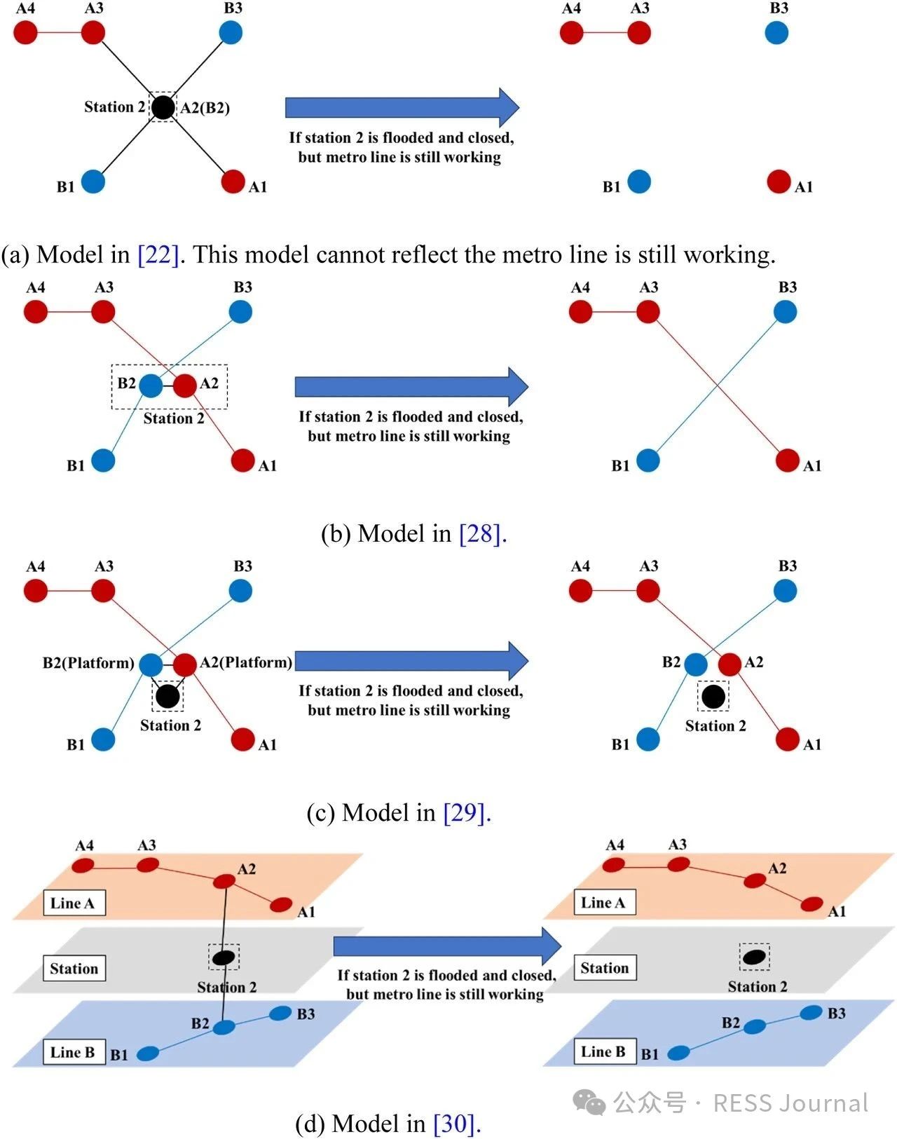
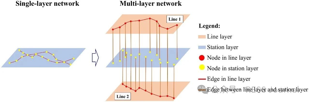
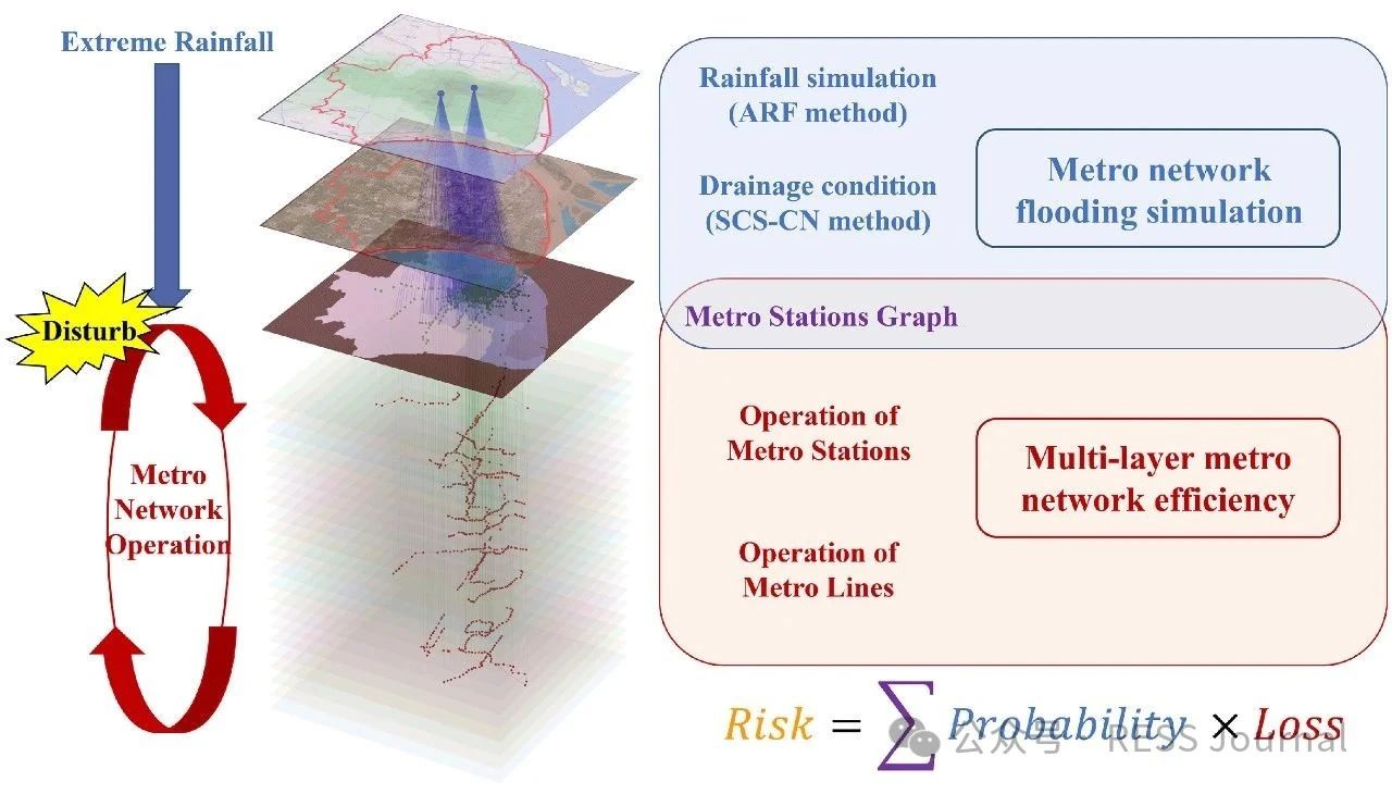
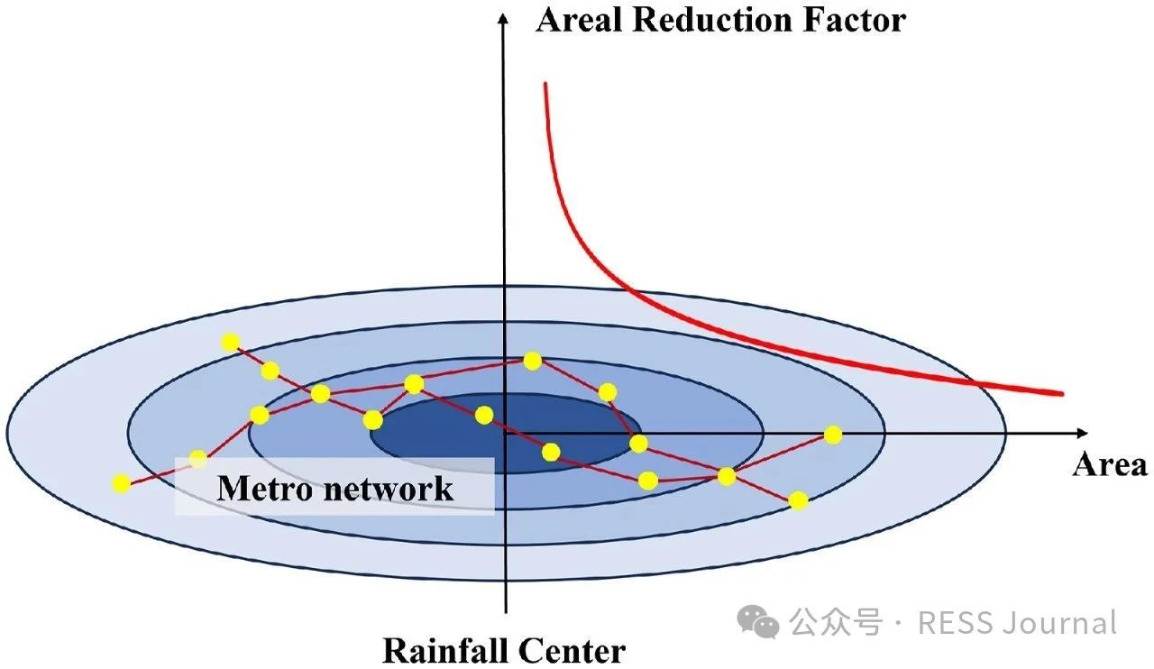
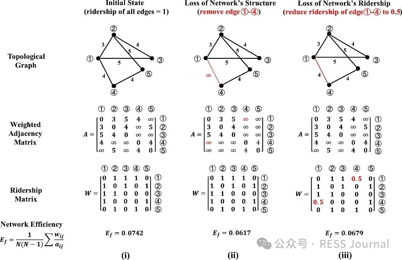
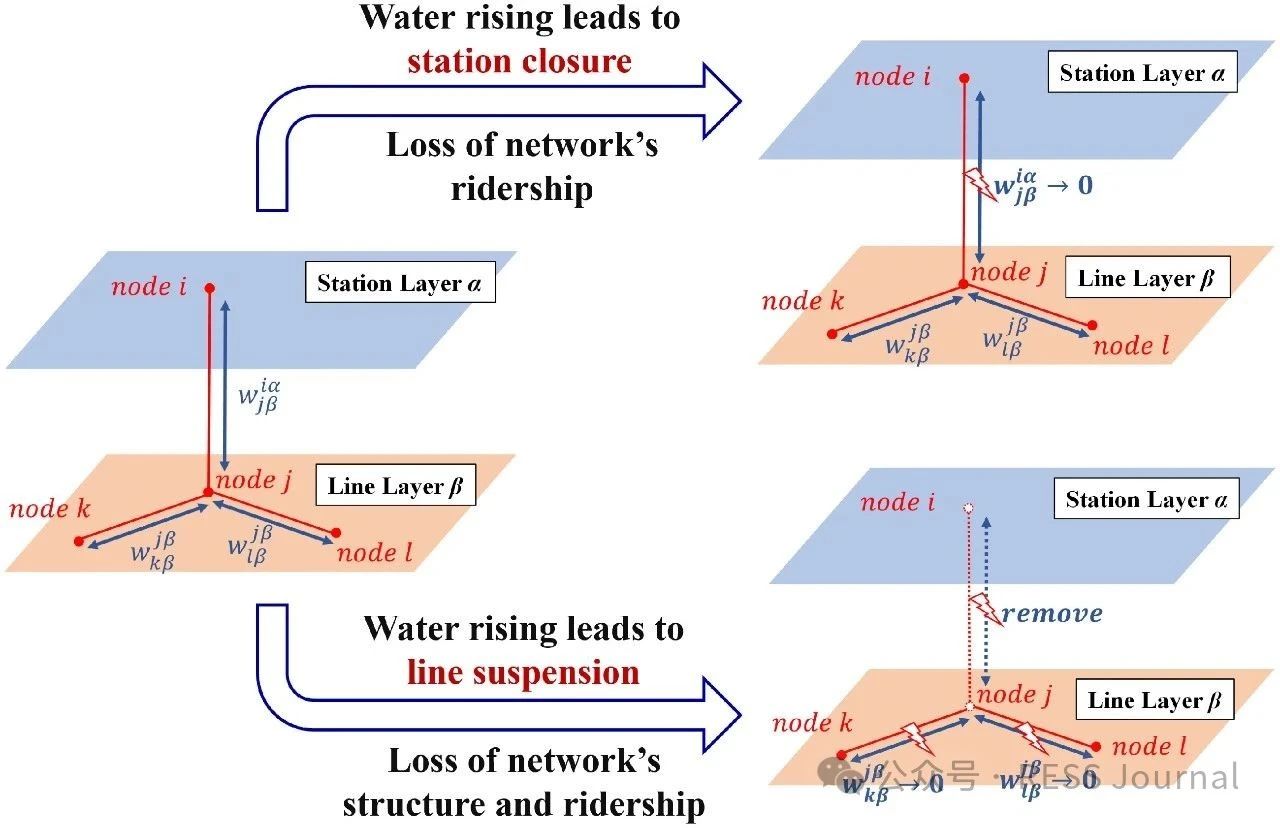
In recent years, a changing climate has induced flood risk as a great threat to the safety and reliability of the metro transit network in mega-cities. A highly networked metro system can lead to a quick spread of this risk, and furthermore, the impact range of single-node accidents of a network is nonlinearly amplified through network connectedness defined by its topology. This study proposes a risk assessment framework integrating extreme rainfall simulation and network loss analysis. The methodology employs the Areal Reduction Factor (ARF) and Soil Conservation Service Curve Number (SCS-CN) to model rainfall-induced flooding, coupled with a multi-layer network-based approach that distinguishes topological interactions between stations and lines. Taking Shanghai metro as an example, this paper highlights its risk follows an exponential distribution to extreme rainfall events, characterized by the finding that nearly 50 % of extreme rainfall events result in <5 % network loss, whereas fewer than 5 % of the events lead to >50 % network loss. When rainfall centers are located in the urban center where metro stations are densely distributed and intricately connected, or when the rainfall intensity and the spatial distribution uncertainty increases, it will pose a greater risk to the metro network.
相关推荐:轨道交通展展位预订 轨道交通展免费报名参观

“十五五”开局之年,金龙汽车集团深入开展“深学争优、敢为争先、实干争效”行动,凝心聚力、真抓实干,实现一季度经营业绩稳中有升、质效齐增,营业收入57.61亿元,同比增长17.04%,利润总额1.75亿元,同比增长185.86%,扣非归母净利润同比增长1085.40%。 全力以赴保生产。一季度伊始,年末订单交付的“攻坚战”如期打响,金龙汽车集团的生产车间内,机器轰鸣震耳、人影往来穿梭,一派热火朝天的奋进景象。从物料供应到技术保障,从品质管控到物流发运,该企业牢牢抓住订单冲刺的黄金窗口期,全力保生产、保交付。新春佳节,当国内万家灯火团圆相聚时,该企业许多海外一线工作人员仍坚守在异国他乡的岗位上,全力做好海外订单交付、客户服务及项目衔接工作。 深耕全球拓市场。金龙汽车集团持续稳存量、拓增量,全力跑出市场开拓“加速度”,一季度累计销售各类车辆12184辆,同比增长8.6%。作为中国客车出海“主力军”,该企业一季度出口业绩再创新高,汽车出口9747辆,同比增加37.4%,海外市场占有率稳居行业第一。其中,446辆金龙客车批量装船发往沙特,助力当地公共交通绿色转型;462辆金旅客车顺利发运,正式交付突尼斯公交集团;3000辆苏州金龙高端客车交付阿尔及利亚,总金额...
合作邮箱:chinaiut@sgexpo.cn
新闻热线:021-3114 8748
广告/媒体合作:13916277698
转载内容版权归作者及来源网站所有,本站原创内容转载请注明来源
Copyright © 晟格会展(上海)有限公司 版权所有 Powered by Tp沪ICP备18026942号-6 ![]() 沪公网安备 31011302006543号
沪公网安备 31011302006543号


